Mending Wall north to Larkmead Lane.
2 Big air tankers in the air at the scene 1 drop so far Near Larkmead Lane
I don’t know how accurate these maps are, but that’s looking pretty scary for Mending Wall and neighbors. https://twitter.com/ai6yrham/status/1310253573075156992
It burned around Mending Wall. I do fear for some of our neighbors in the amphitheater around back
A good friend who manages Girard up in Calistoga, right at the top of the trail, said it’s about a mile away, to give context.
Down here in Napa (City of) I’m starting to smell smoke.
Well that’s some great news for Mending Wall! ![]()
Up to 800 acres with evacuations of patients from Adventist Hospital in St. Helena, per CBS in San Francisco. Good luck to everyone up there!
Hearing reports the fire has jumped Silverado Trail at Dunaweal Lane. ![]()
From SF news station KRON:
The County of Napa has issued evacuation orders for thousands of people. Anyone in the following areas need to leave immediately.
All of Crystal Springs Rd and North Fork Crystal Spring Rd.
Silverado Trail from Larkmead Ln to Deer Park Rd.
Deer Park Rd to Crystal Springs Rd
Deer Park Rd to Devils Elbow
Eastside of Silverado Trail from Larkmead Rd to Deer Park Rd. This includes both sides of Deer Park Road up to Crestmont Drive including Sanitarium Road.
College Avenue at Howell Mountain Road to White Cottage Road and all of Freisen Drive, including all roads west of College Avenue and Freisen Drive.
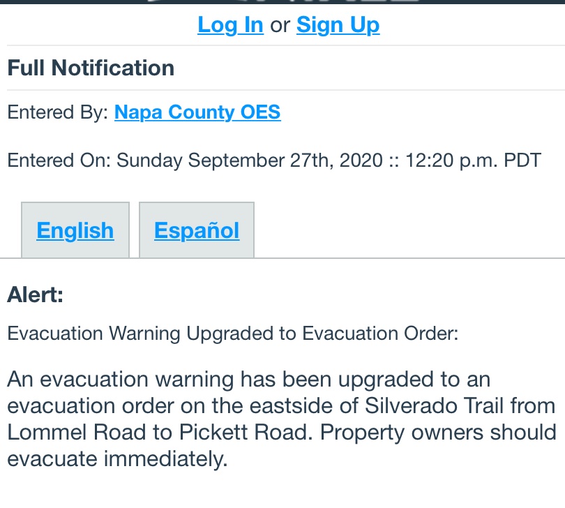
All of Lommel Road
They got this one out quickly. Great job!
Any word on Outpost?
A friend in Sonoma mentioned waking to this too … so sad to see …
Thanks for updating!
CNN just reported fire is now at 1000 acres. This is getting depressing.
CalFire now has it at 1,500 acres. Meadowood Resort just ordered to evacuate.
Evacuation warning just extended south to Taplin Road (for those unfamiliar - Joseph Phelps winery is on Taplin). This is a warning not a mandatory evacuation order.
Has anyone heard from Merrill? I saw earlier Pickett Road area was either in or close to the mandatory evacuation zone.
Yes, Merrill is either just outside or just inside the northwest edge of the mandatory evacuation zone (sources disagree whether it ends at Pickett road or extends a little bit farther). That zone boundary has been pretty stable, which suggests fire has not been moving in that direction.
-Al
Been wondering about Merrill too. Sometimes after harvest she heads to Boston I think. For the locals: how’s the wind?
According to Ehren/Failla on Facebook, it got within 500’ of the crush pad, but no structures damaged.
Tom
You got it right, Casey. I am at the beach with a nice glass of Champagne in hand. Have not heard from my housekeeper yet. The electicity went off this morning around 4-5:00, so I packed by candlelight. Are we having fun yet? 