Thank you!
Indeed https://weinlagen-info.de/ is the only one that covers virtually the whole world. Of course, It’s not complete. It focuses mailny on the regions where singel vineyards are relevant. But there are 11000 of them, with bouderies and all. And it leverages everything you get from google maps: satelite, street view (if any in the region).
Indeed, it s not really good for pinning on a wall.
Alessandro said an updated version of Vol I will be out late this year.
That will be nice because some of the specifics of the MGA system weren’t entirely settled when it was first published (unlike the Barbaresco book, which was published later).
Thank you Ken. I won’t miss it this time. I just finished listening to Levi Dalton’s interview with him on I’ll Drink to That this morning. Interesting story.
I love the links! I got lost in the german section for quite a while last night. I love that there are times it even tells which producers are making wines in individual vineyards. being able to zoom in and out and see how the vineyards and regions relate to each other, that is so useful and educational.
I understand that this is not a resource for European countries, but I wanted to share it somewhere.
I have been searching for the City of Oakley’s mapping of vineyards (part of the ACVP Phase 1 project), and I found this neat site. It doesn’t label the agricultural land parcels individually. Still fun…
CA Farmland Mapping and Monitoring Program
“This map layer shows the designations of the California Farmland Mapping and Monitoring Program.”
I’ve had it for many years now. I believe it used to be on the CdP tourist “welcome” website and that I just emailed to page administrator for contact info for ordering it. He was quite nice and helpful.
+1
World Atlas of Wine by Hugh Johnson & Jancis Robinson. Has excellent index and also commentary of each locale. Available hard cover or eBook.
Probably one of the best globally. If you are focused on specific region outside the mainstream there may be better specialty maps. See all the other posts here.
+1
World Atlas of Wine by Hugh Johnson & Jancis Robinson. Has excellent index and also commentary of each locale. Available hard cover or eBook.
Probably one of the best globally. If you are focused on specific region outside the mainstream there may be better specialty maps. See all the other posts here.[/quote]
I love my World Atlas. The one thing that irks me just a little is the changing in orientation that happens often, like in the Cote d’Or. Its a small thing, but i dont really understand the need for it
"Diversity and soil properties of France
• Soil diversity of France
• The diversity of forest soils and humus
• Soils properties of France
• The total major elements of the soils
• The stoniness of the grounds
• Carbonates in soils
• Carbon and soil organic matter
• Soil biodiversity
• Mineralogy of soils
• Soil texture
• Depth of soil
"Degradation and soil loss
• Soil losses
• Soil erosion
• Contamination in metallic trace elements (ETM)
• Pathogens in soils
• Persistent organic pollutants and pesticides
• Artificialisation and waterproofing of soils
• Soil compaction
"Soils and the water cycle
• Water in the soil
• Useful soil water reserve
• Phosphorus in soils
"Soils in the face of climate change
• Soils in adaptation to climate change
• Soil and greenhouse gas emissions
• Carbon and soil organic matter
• Useful soil water reserve
"Soils supporting agricultural and forestry productivity
• Forest soils
• Soil compaction
• Chemical fertility of soils
• Useful soil water reserve
• Depth and pebble load of forest soils "
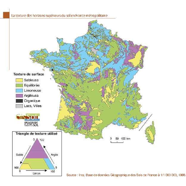
"The Texture of the Upper Horizons of Soil in Metropolitan France
"The sandy soils are located mainly in the Landes, Sologne and Vosges where they are the support of large forest areas. They are also present in the Massif Central, developed on granite arenas. Balanced textures dominate in Champagne and the southern half of France.
"The silty textures are mostly present in the northern half of France and the clay textures in Lorraine and the South-West.
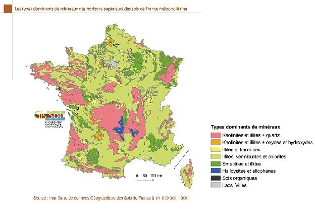
"Dominant Types of Minerals from the Upper Horizons of Soils of Metropolitan France"
"In metropolitan France, quartz is the dominant element in many soils. Inert, it deteriorates very slowly. It characterizes for example the sandy soils of the Landes and Sologne. The crystalline rocks, eruptive or those resulting from metamorphic transformations, are characterized during their alteration by the formation of soils with sandy texture according to the local conditions of which the intensity of the argilisation process varies (Armorican Massif, Massif Central, Vosges). Most metropolitan soils contain residual minerals from the rocks from which they derive, in particular illites and chlorites. The shallow soils developed on carbonate rocks show a mineralogy dominated by the carbonates inherited from the rock. Neoformed minerals are also present, mainly vermiculites. To all these types are joined oxides of iron, aluminum and manganese.
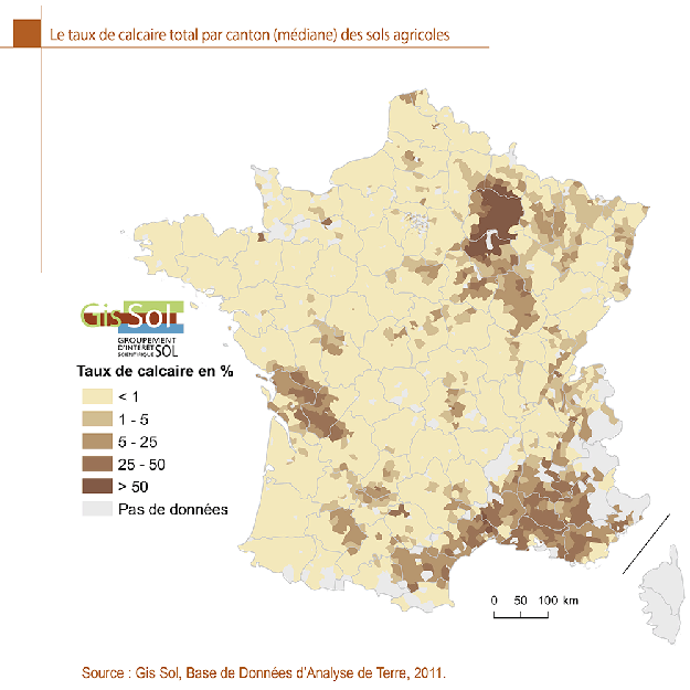
“The Total Limestone Rate per Canton (Median) of Agricultural Soils”
"The map extracted from the Earth Analysis Database (BDAT) illustrates the distribution of limestone in agricultural soils, strongly linked to chalk (Champagne), marl (Argonne, Woëvre) and hard Jurassic limestones (Alps , Berry, Burgundy, Jura, Poitou and Provence).