↑↑ All information on the GIS SOL website ↑↑ is in French. I went ahead and translated the above stuff since I am from Louisiana, and everybody in my state is fluent in the language from birth. ![]()
Just kidding! I have a Google feature that automatically translates almost any non-English web page on my phone. I took five years’ worth of Spanish in high school and college, and I have lost ~90% of it through the ravages of time.
USGS Mineral Resources Online Spatial Data
“Interactive maps and downloadable data for regional and global analysis.”
★ Map of US GIS: Mineral Resources (Geological Features) Spatial Data:
https://mrdata.usgs.gov/geology/state/map-us.html#home
The Globe Icon allows you to select where you want to view on the map. I suggest that you start there.
From the Help Menu:
"Explore the Data:
"• Click the map to show data near to the point you clicked.
• A report opens in a new window.
• Click the section headings to expand or collapse reports.
• To select data from a rectangular area, hold the Ctrl key and drag the pointer.
• Don’t search a large area this way, it takes too long. Zoom in instead.
FYI The Rare Wine Co. is taking orders for the updated Vol 1.
Or you can buy it directly from Enogea in Europe and they will ship here:
Maps of the Past Shop: “Old County Maps, California” (most are landowner parcel maps c1870’s-'80s):
Not a map, but…
Does anyone recall a post with a link to a video of an aerial view of Bordeaux that traveled up the river and zoomed in on some areas? It may have been a computer simulation incorporating Google Earth data IIRC. I thought I’d seen it on WB but have failed in my attempts to search for it.
Many of the Napa maps are laid out according to AVA. Piper has a much better sense of where the lines should be drawn. See if he can repost. My location has absolutely nothing in common with some other Calistoga Vineyards, which is why I bottle my wines under the Napa Valley AVA.
On the subject, there was a website that showed all the vineyards in Napa. You could click on the corresponding vineyards and it would tell you who was the grower. Anyone know of this and where I can find it?
Any maps of the single vinyards of Rioja?
This is exactly what I was looking for. Thank you so much. 
Here is a good website for maps:
Charlie would it be possible to add a layer showing the owners in the different vineyards?
I think Coates did that in Clos de Vougeot, bot it is rarely seen
I know off course it is a big job
Sure, by adding sub-vineyards in the single vineyard. I did it in Clos de Vougeot Weinlagen
But usually you donts have that information. In Germany, they would not disclose it.
So if you have that info for any vineyrad, just drop me a note.
Tagging this for invaluable resource category. Thanks everyone!
Mike
Wine Maps! — Fernando Beteta, MS (Beaujolais,Chenas……)
https://www.dalluva.com/wp-content/uploads/2015/01/Official-Barolo-Map.pdf
https://www.dalluva.com/wp-content/uploads/2015/01/Official-Barbaresco-Map.pdf
https://www.dalluva.com/wp-content/uploads/2015/01/Official-Diano-d-Alba-Map.pdf
» Montrachet, ses parcelles et ses propriétaires
http://lefrancbuveur.com/chronique-livre/chronique-livre-mes-incontournables-5-de-5/attachment/dscn2439/
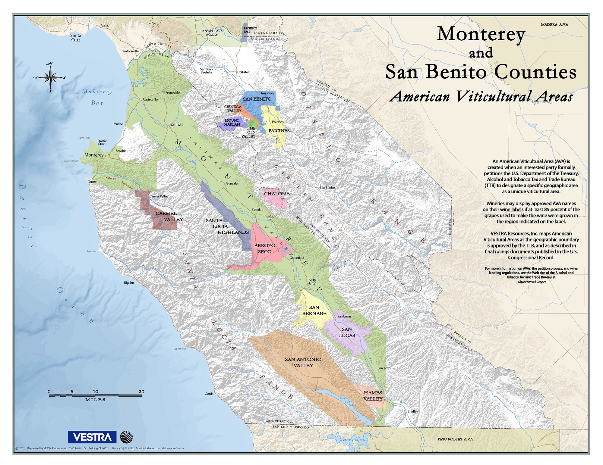
VESTRA
"Monterey and San Benito AVA Map"
Here are a few more resources for exploring maps of wine regions:
· Wine Scholar Guild blog
Tagged posts: “Wine Maps” (various European wine regions)
· Winehog
“Terroir and Geology – What Do We Know? – Knowing More!”
by Steen Öhman
February 16, 2018
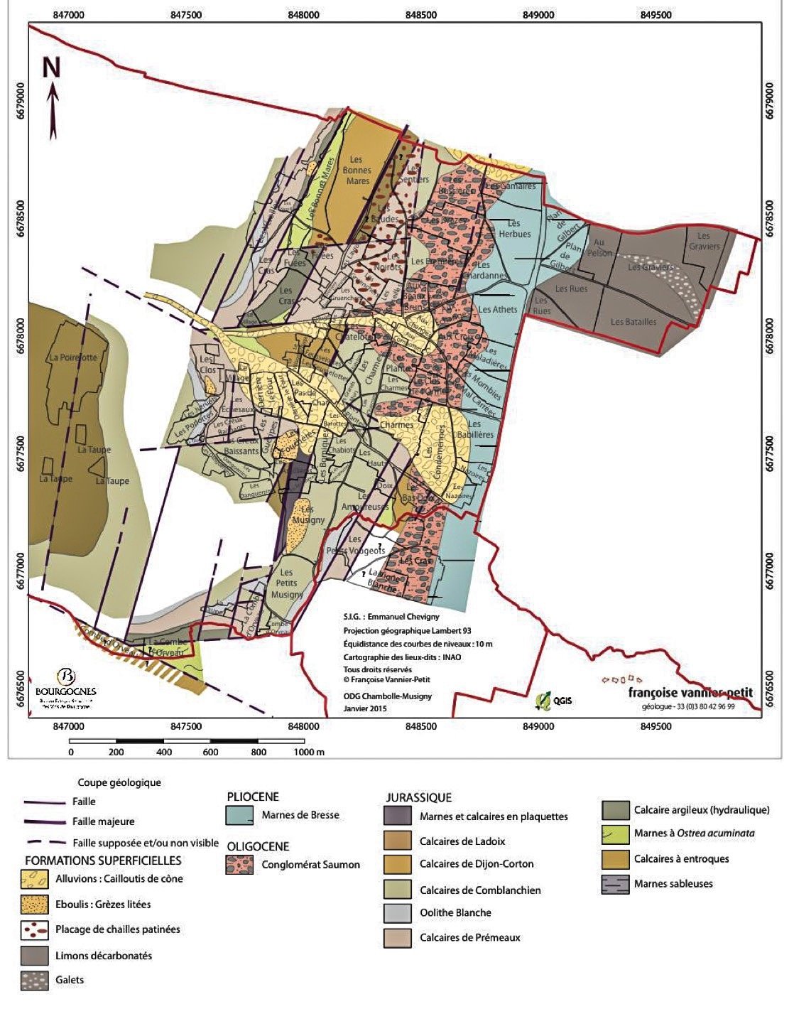
· Monocepage:
“Geology of Chambolle-Musigny” (in French)
August 17, 2016
· University of Texas Austin
Perry-Castañeda Library, Map Collection:
“California Topographic Maps”
· Sonoma County Tourism
“2015 Wineries Map” (downloadable file)
· Stanford University Libraries
"Map of the Calistoga or Little Geysers and the Hot Sulphur Springs, Napa County California. Surveyed by T.W. Morgan. Lith. by Britton and Rey, S.F" (1853-1997)
· Stanford University Libraries
“Portion of San Mateo / Santa Cruz Counties showing land ownership, many of which are lumber companies” (1853-1997)
· California Dept of Conservation
“CA Important Farmland Time Series” Map (scroll to the left at the bottom of each map area to view changes in farmland and urban growth in recent years)
· ProPublica
“New Maps Show How Climate Change is Making California’s ‘Fire Weather’ Worse”
by Al Shaw and Elizabeth Weil
October 14, 2020
If you subscribe to Jancis you have access to all the World Atlas of Wine maps included.
1 Like