· UC Santa Barbara Library
Map and Imagery Lab Aerial Imagery Applications:
“Aerial Photography Catalog”
https://mil.library.ucsb.edu/apcatalog/
· UC Santa Barbara Library
Geospatial Catalog: “California Aerial Photography by County”
https://www.library.ucsb.edu/geospatial/airphotos/california-aerial-photography-county
· USGS
“New Land Cover Maps Depict 15 Years of Change across America”
https://www.usgs.gov/news/new-land-cover-maps-depict-15-years-change-across-america
· Sonoma County Veg Map
“1942 Aerials of Sonoma County - Santa Rosa Plain”
http://sonomavegmap.org/blog/2014/08/16/1942-aerials-of-sonoma-county-laguna-de-santa-rosa-watershed/
· USGS National Geologic Map Database
https://ngmdb.usgs.gov/ngmdb/ngmdb_home.html
· USGS National Geospatial Program
“Historical Topographic Map Collection”
https://www.usgs.gov/core-science-systems/ngp/topo-maps/historical-topographic-map-collection?qt-science_support_page_related_con=0#qt-science_support_page_related_con
· Napa County Resource Conservation District
Resources: “Mapping Tools”
https://naparcd.org/resources/category/mapping-tools/
· National Center for Atmospheric Research
What We Offer: “Models”
https://ncar.ucar.edu/what-we-offer/models
· Santa Clara County Government site
Office of Planning and Development: “Cadastral Maps”
https://www.sccgov.org/sites/dpd/DocsForms/Documents/Surveyor/Pages/CadastralMaps.htm
· Santa Clara County Government site
Office of Planning and Development: “1876 Santa Clara County Wall Map”
https://sccgov.maps.arcgis.com/apps/StorytellingSwipe/index.html?appid=c8e3dba109be45f2a9abcc157540353c#
Szekszárd Vineyard Map
Here are two more internet repositories for maps of various wine grape-growing regions:
Norman B. Leventhal Map & Education Center
Search Results for: “Geological Survey of California” (5 maps from 1870s)
OMNIA: Europe’s Culture in One Place
The OMNIA website allows you to peruse hundreds of institutions’ archived documents (including maps) or to perform general searches. Quite the overwhelming resource!
California Agriculture 54(3):7-12
“Mapping Vineyard Expansion Provides Information on Agriculture and the Environment”
by Adina Merenlender, UC Berkeley
May, 2000
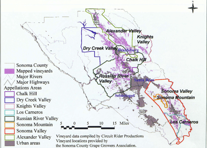
“Vineyards Mapped within the Major Appellation Areas”
“Vineyards mapped within the major appellation areas of Sonoma County, including Alexander Valley, Russian River Valley, Chalk Hill, Dry Creek Valley, Knlghts Valley, Los Carneros, Sonoma Mountain and Sonoma Valley.”
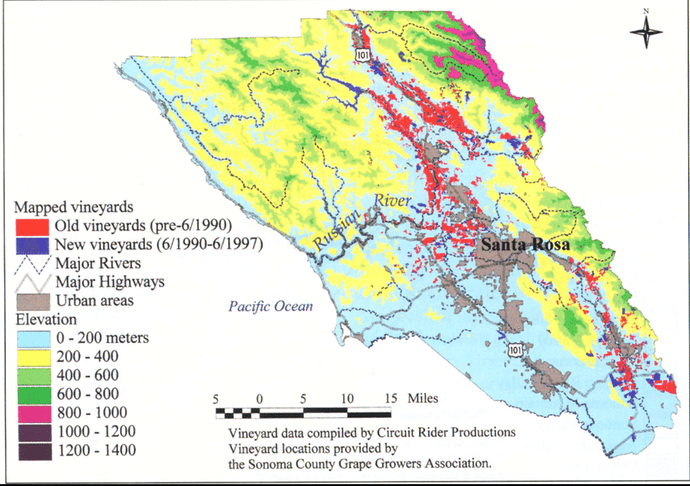
“Vineyards in Sonoma County with Elevation Classes”
“Vineyards mapped from 1990 aerial photos are in red; those mapped by the grape growers as newly developed since 1990 are in blue.”
I am in awe of the effort devoted to researching, collating, and cross-referencing of data conducted for this piece of research!
The true shame of it all is that the maps, and the vineyards represented, are barely visible. I might reach out to the authors and humbly request larger copies of the images, if available.
As there is no apparent master thread for the wineries and vineyards of Santa Barbara AVA, I am sharing this resource on this thread:
Google Maps
“Santa Ynez Valley Wine Country Map”
“Map of vineyards, wineries, and tasting rooms in the Santa Ynez Valley area.”
The creator of this map is unknown. I neither can determine when it was made.
I am surprised that I had not discovered this internet resource prior to this morning! The following UC Davis Library site provides an organized and accessible collection of online mapping tools.
UC Davis Library
Mapping & Cartography Service website:
https://www.library.ucdavis.edu/service/mapping-cartography/
“The Data Management Program offers services related to mapping, cartography, and geospatial data visualization.”
Selected Data Sources
· USGS EarthExplorer
· USGS National Map Viewer
· Geographic Names Information System (GNIS)
· Library of Congress Digital Map Collections
· Cal-Atlas Geospatial Clearinghouse
· Data.gov
Related Guides
· Maps, Mapping, and GIS
“A guide to the resources and services for those studying and applying spatial information. These include physical map collections, GIS resources and tools and services, and a vast array of geographic and cartographic material across the UC Davis Library.”
· Geography
“Geography is a multi-disciplinary field. This guide introduces students to a variety of resources for the study of human and physical geography…”.
· Geospatial Data for Storage & Exchange
“This guide discusses storage and exchange formats for geospatial data.”
Additional GIS Data Sources
· Local & Regional
· State
· National
· Global & International
UC Davis Library website:
https://www.library.ucdavis.edu/
The ability to observe changes in viticultural landscapes over time can aid the identification of at-risk grape-growing sites and, possibly, determine which locations are more likely to succumb to urban-rural pressure.
USGS
“Atlas of Urban and regional change, San Francisco Bay region, Alameda, Contra Costa, Marin, Napa, San Francisco, San Mateo, Santa Clara, Solano, and Sonoma counties, California” (1973)
Open-File Report 73-322
44 Plates
Alternate link:
The “Atlas of Urban and regional change” series of maps (“plates”) neatly outline where vineyards were found in 1973. A post on the “Contra Costa Wine Heritage” thread demonstrates one way that this tool can be applied to understand the loss of “Agriculture - Vineyard, Orchard” parcels. Some knowledge of specific vineyard locations is helpful in this instance.
· “USGS Geological Survey 671” (downloadable PDF)
· USGS
Professional Paper 964
“A Land Use and Land Cover Classification System for Use with Remote Sensor Data”
A revision of the land use classification system in “Circular 671”
by James R. Anderson, Ernest E. Hardy, John T. Roach, and Richard E. Witmer
Alternate link:
A land use and land cover classification system for use with remote sensor data"The framework of a national land use and land cover classification system is presented for use with remote sensor data. The classification system has been developed to meet the needs of Federal and State agencies for an up-to-date overview of land use and land cover throughout the country on a basis that is uniform in categorization at the more generalized first and second levels and that will be receptive to data from satellite and aircraft remote sensors.
"The proposed system uses the features of existing widely used classification systems that are amenable to data derived from remote sensing sources. It is intentionally left open-ended so that Federal, regional, State, and local agencies can have flexibility in developing more detailed land use classifications at the third and fourth levels in order to meet their particular needs and at the same time remain compatible with each other and the national system.
"Revision of the land use classification system as presented in ‘U.S. Geological Survey Circular 671’ was undertaken in order to incorporate the results of extensive testing and review of the categorization and definitions."Data from the Important Farmland Time Series map, a project developed by the CA Dept of Conservation’s Farmland Mapping & Monitoring Program, can be used in combination with the above resource as means of tracking vineyard land loss and change over the decades.
Lincoln Instite of Land Policy
“Atlas of Urban Expansion”
https://www.lincolninst.edu/research-data/data/atlas-urban-expansion
"The Atlas of Urban Expansion is an open-source online resource with maps, satellite images, and data on spatial changes in cities around the world, created in partnership by the Lincoln Institute of Land Policy, UN-Habitat, and New York University.
"The Atlas of Urban Expansion features a global sample of 200 cities, representing the universe of all 4,231 cities and metropolitan areas that had 100,000 people or more in 2010. The aim is to provide a scientific understanding of how the world’s cities are growing, and to measure performance and identify trends in the implementation of the New Urban Agenda following the Habitat III global cities summit held in Quito, Ecuador in October 2016.
"Massive urbanization, accompanied by the rapid expansion of cities and metropolitan regions and the sprawling growth of megacities the world over, is one of the most important transformations of our planet. Much of this explosive growth has been unplanned. Cities in developing countries have been unprepared for absorbing the many millions of the rural poor that are still crowding into informal settlements. These cities are set to double their urban population in the next thirty years, and triple the land area they occupy. From 1990 and 2015, the area occupied by cities in less developed countries increased by a factor of 3.5; if that rate continues, the total amount of land taken over by urban land use would be equivalent to the entire country of India.
"The Atlas of Urban Expansion provides the geographic and quantitative dimensions of urban expansion and its key attributes in cities the world over. The data and images are available for free downloading, for scholars, public officials, planners, those engaged in international development, and concerned citizens. The empirical data and quantitative dimensions of past, present, and future urban expansion in cities around the world are critical for making minimal preparations for the massive urban growth expected in the coming decades.
“Related publications include the Atlas of Urban Expansion 2016 Volume I and Volume II; Planet of Cities (2012); Atlas of Urban Expansion (2012); and the Policy Focus Report Making Room for a Planet of Cities (2011).”
USGS: Western Geographic Science Center
“The LUCAS Model”
"The Land Use and Carbon Scenario Simulator (LUCAS) tracks changes in land use, land cover, land management, and disturbance, and their impacts on ecosystem carbon storage and flux.
"The LUCAS model combines:
· State-and-Transition Simulation Model to simulate changes in land-use across a range of geographic scales.
· Stock and Flow Model to track the movement of carbon between different ‘pools’ including interactions between land and atmosphere.
· Linkage to the Integrated Biosphere Simulator (IBIS) dynamic global vegetation model."
The Santa Barbara Vintners website offers several AVA maps - but not for free. Electronic copies are less expensive than print versions. Neither price is unreasonable.
https://sbcountywines.com/map-store/
A “free” downloadable PDF vineyard map of Santa Ynez Valley AVA, compliments of Dierburg Vineyard’s website:
“Santa Ynez Valley AVA Map” (PDF download)
Ballard Canyon AVA website: “Map”
Santa Barbara Vintners website:
https://sbcountywines.com/
TTB Interactive AVA Map website:
https://www.ttb.gov/images/AVA/
CA Dept of Conservation
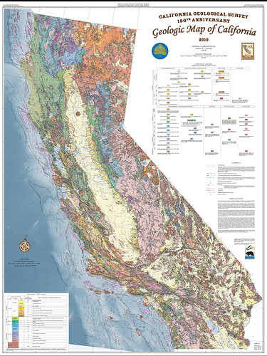
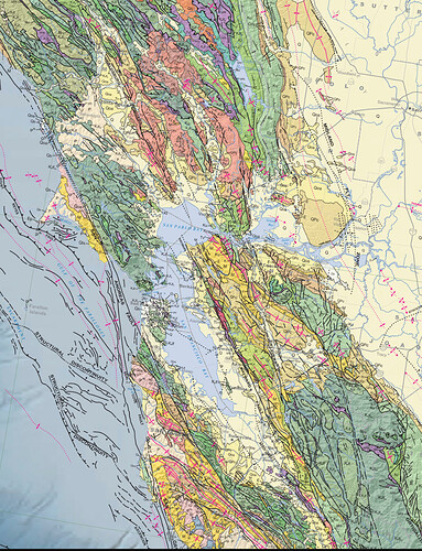
2010 Geologic Map of California:
https://www.conservation.ca.gov/cgs/publications/geologic-map-of-california
"2010 Geologic Map of California
“The 2010 Geologic Map of California and the Fault Activity Map of California were prepared in recognition of the California Geological Survey’s 150th Anniversary. Both are all-digital products built on the original compilations of C.W. Jennings published in 1977 and 1994. The digital version of the Jennings (1977) geologic map was released in 2000 (Saucedo and others, 2000) and serves as the base digital geologic data layer for the geologic map with additions and modifications described below. These editions remove, as much as possible, distortions in the previous digital versions that were inherited from the composite base map of the original printed versions…”.
CA State Map Preview (download):
SF Bay Map Preview (download):
Interactive Geologic Map:
California Department of Conservation website:
I downloaded a bunch of Burgundy maps years ago (can’t even remember from which producer). They’re pdf; I can send you some files if you want.
I’ll find them and send you a list.
Pretty detailed on Burgundy: Bourgogne Maps, an interactive atlas of Bourgogne wines - Bourgogne wines
I was able to buy printed maps with similar levels of detail in Beaune, but haven’t been able to find an online source.
I see a lot of the Vinous maps when I taste in Napa Valley. They are beautiful and detailed, yet the wineries concede they are only accurate until a property is acquired.
UC Berkeley Library
Digital Collections
California Maps Produced by Edward Denny
“Denny’s Pocket Map of Solano County, California, Compiled from Latest Official and Private Data”
Published: San Francisco, Edward Denny & Co., 1915
“Denny’s Pocket Map of Sonoma County, California, and portions of Lake, Napa and Marin counties”
Published: San Francisco, Edward Denny & Co., 1907
“Denny’s Pocket Map of Alameda County, California, Compiled from Latest Official and Private Data”
Published: San Francisco, Edward Denny & Co., 1914
“Map of the City and County of San Francisco”
Published: San Francisco, Edward Denny & Co., 19??
“Denny’s Pocket Map, Santa Clara County, California, Compiled from Latest Official and Private Data”
Published: San Francisco, Edward Denny & Co., 1913
“Denny’s Pocket Map of San Mateo County, California, Compiled from Latest Official and Private Data”
Published: San Francisco, Edward Denny & Co., 1913
UC Berkeley Library
Digital Collections
Maps by Real Estate Data, Inc
Stanford University Library
The Barry Lawrence Ruderman Map Collection
Maps of California Counties by C.F. Weber & Co.
Some digital resources from the National Archive of American History’s “American Wine Documentation Project” are available online via the Smithsonian Online Virtual Archives website, including two Stag’s Leap Wine Cellars vineyard grid maps.
Smithsonian Online Virtual Archives:
“Guide to the American Wine Documentation Project”
"Scope and Contents:
"The collection is divided into six series. It includes mostly printed materials and interviews, and dates from approximately 1976 to 2005. There are wine-related event materials, interview transcripts and audiotapes, printed material and histories from people and institutions representing a wide spectrum of the wine business. Wine-related objects, such vineyard and winery tools, are stored with the Museum’s artifact collections; documentary materials are held in the Archives Center. Materials from each special event are organized into separate series, which contain records generated at the events and interviews.
“Series one contains the ‘Red, White and American Records’, series two the ‘Collectors Event’, and series three the ‘Wine Writers Event’. Interviews conducted independently of these events are included in series four. All of the interviews have been partially transcribed and include an abstract and various forms of audiotapes and discs. Series five is composed of printed materials that relate to both specific individuals in the wine business and to more general American wine topics. Most of this material consists of photocopies of original articles. There are also files with materials by and about specific wine writers, such as Anthony Dias Blue, William Heinz, and Dick Rosano. Series five also contains an original telex of George Taber’s article about the 1976 Paris Tasting. Series six consists of visual materials, including two landscape photographs of an vineyard in Oregon and two videotaped documentaries on Napa.”
"Scope and Contents:
"The Stag’s Leap Wine Cellars (SLWC) Documentation Project was conducted by an inter-disciplinary team at the National Museum of American History. It is a part of a larger effort by the Museum’s American Food and Wine team to document and interpret the changing ways in which Americans have produced, prepared, and consumed their food and drink, especially in the years after World War II. Team members are Nanci Edwards (Office of Project Management and former Collections Manager of the Museum’s Agriculture Collection), John Fleckner (Senior Archivist, Archives Center), Rayna Green (Curator, Division of Home and Community Life), and Paula Johnson (Curator, Division of Work and Industry). Jeff Tinsley of the Smithsonian’s Office of Photographic Services accompanied the team and shot many of the slides and color photographs.
"This collection chronicles the growth and development of American viticulture and viniculture from its revival in the 1960s to the present. It offers a case study in the art and business of making fine wine from the bud to the bottle. Warren Winiarski, founder of SLWC in California’s Napa Valley, is deeply interested in the legacy of American winemaking and his winery’s place within its broader history. The Winiarski family has generously participated and financially supported the creation of this collection.
"The documentation touches on all aspects of the wine business, including picking grapes in the vineyards, making wine in the cellar, marketing it from the business office, and promoting its sales in the tasting room and around the globe. SLWC employees describe the land, the work, the tools, the technical processes, the passions, and the motivations that create SLWC’s world famous wines. The collection also provides insights into wider patterns of American immigration history, agricultural and environmental history, ethnic community development, land use in the West, product marketing, and consumerism.
"The archival collection is mainly comprised of recorded oral history interviews, documentary photographs, and video footage created by the documentation team in 1997. It also includes company newsletters, vineyard and winery production data sheets, wine labels, and related printed materials collected in 1997 with additional materials added occasionally.
“It is divided into seven series, including interviews and abstracts, audiotapes, photographs and slides, videotapes, business records, and printed materials.”
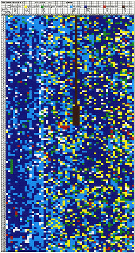
SLWC “Computer-Generated Color-Coded Vineyard Block Diagrams”
- SLWC “Fay Vineyard 2B & 2C”
(NMAH-AC0816-0000022) - SLWC “S.L.V. 3”
(NMAH-AC0816-0000023)
National Archive of American History
Behring Center
Collections:
“Stag’s Leap Wine Cellars Documentation Project, 1960-2006” (NMAH.AC.0816)
“SLWC Vineyard Block Maps”:
Slideshow:
https://edan.si.edu/slideshow/viewer/?eadrefid=NMAH.AC.0816_ref123
(PDF download)
Stag’s Leap Wine Cellars website:
“Vineyards”:
Not sure this does it for you as you need the key that is down below, but this is a good one for Montalcino
http://casavacanze.poderesantapia.com/album/montalcino/brunellodimontalcinomappa.htm
The National Geospatial Program is described as “A U.S. Geological Survey (USGS) trusted digital repository providing access to scientific data products and resources.”
USGS Science Base
National Geospatial Program
https://www.sciencebase.gov/
· “About”
“…ScienceBase provides access to aggregated information derived from many data and information domains, including feeds from existing data systems, metadata catalogs, and scientists contributing new and original content. ScienceBase architecture is designed to help science teams and data practitioners centralize their data and information resources to create a foundation needed for their work. ScienceBase, both original software and engineered components, is released as an open source project to promote involvement from the larger scientific programming community both inside and outside the USGS.”
· Catalog
· The National Map (Folder View)
Search Results: “Topo Map California”
